i-Boating:Marine Navigation PC
Gps Nautical Charts
Download i-Boating:Marine Navigation on PC With GameLoop Emulator
i-Boating:Marine Navigation on PC
i-Boating:Marine Navigation, coming from the developer Gps Nautical Charts, is running on Android systerm in the past.
Now, You can play i-Boating:Marine Navigation on PC with GameLoop smoothly.
Download it in the GameLoop library or search results. No more eyeing the battery or frustrating calls at the wrong time any more.
Just enjoy i-Boating:Marine Navigation PC on the large screen for free!
i-Boating:Marine Navigation Introduction
This Marine Charts App offers offline nautical charts, inland river navigation charts, and lake contour maps for fishing,kayaking, yachting & sailing.
First marine navigation app to have boat route assistance with Voice Prompts. All features of a Marine Chart plotter in one app!
It supports Nautical Charts course up orientation. Incl Tide Charts & Currents prediction for nautical navigation.
Create new boat routes / Waypoints, or import existing GPX/KML routes on device. Has Marine AIS(NMEA) support.
►FEATURES
√ GPU accelerated offline vector NOAA charts/ENC charts (text stays upright on rotation)
√ Lake depth map shading/safety lake depth contours:custom boat safety depth
√ Maritime Aids to Boat Navigation : Beacons,Buoys,Boat Launch areas,Boat Ramps,Marina, Fishing Attractors
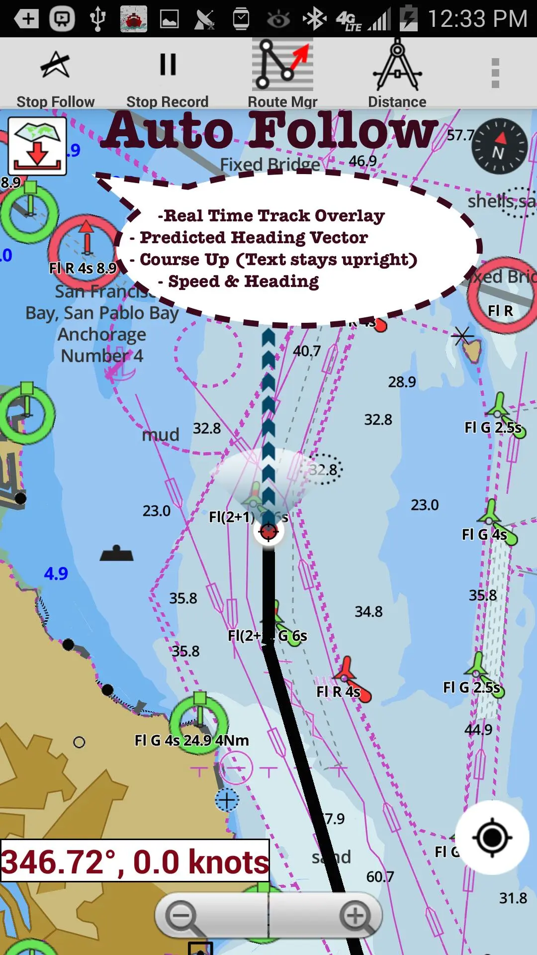
√ Record marine tracks, Autofollow with real-time track overlay
√ Voice Prompts for marine navigation
√ HD 1ft/3ft depth lake contour maps for anglers for selected lake maps: for fishing/trolling(freshwater/saltwater).
√ GPX/KML for boat route.
√ Seamless marine chart quilting: Details from Coastal, Approaches,Harbour & Inland ENC (Electronic Marine Charts)
√ Waypoints
√ Tide & Currents.
√ Marine AIS
√ Anchor Alarm
√ Magnify Text & Icons
√ Wind Prediction Overlay
√ Bearing True/Magnetic
► Fishing Hot Spots AI
► MAPS
All details of marine chartplotters!
Unlimited updates for 1 year.
USA: Maps incl coverage of NOAA marine charts,ENC,USACE inland river maps & freshwater lake bathymetry maps for more than 50K lakes. Charts incl HD/1ft bathymetry for selected lakes. Incl NOAA marine charts(rasters) where NOAA ENC coverage isn't available.
Canada:CHS data Incl Great lakes(US & Canada sides),Alberta & Ontario lakes,Lake Simcoe&Trent Severn Canal,Quebec reservoirs.
UK/Ireland: UKHO marine charts
Germany:BSH charts,Waterways & rivers.
France
Europe Inland Rivers:Donau/Danube/Dunaja,Rhine,Rhein,Garonne,Moselle,Drava,Sava
Australia
Netherland/Holland
Croatia
Finland
Norway
Sweden
Brazil
Spain
Malta,Cypress, Mediterranean Sea
Caribbean
New Zealand
Denmark,Greenland,Faroe
Seychelles,Mauritius,Tanzania
Falklands
Malaysia,South China Sea
Persian/Arabian Gulf,Red Sea
South Africa
Argentina
Iceland
Fiji
Estonia,Latvia,Poland,Lithuania
Turkey,Greece,Italy
►Instrumentation
√ Marine AIS & (NMEA AIS and GPS over TCP/UDP)
√ Wind direction & Speed,Marine Sonar depth,Water temperature
►ROUTE MANAGEMENT/TRIP PLANNING
√ Create/Edit/Reverse Boat Routes
√ Waypoints mgt
√ Import GPX,KML & KMZ files
√ Share/Export Routes,Boating log, Tracks&Markers
►FEATURES for BOAT NAVIGATION
√ Auto Follow
* Real Time Overlay & Predicted Path Vector
* Course Up
* Speed & Heading
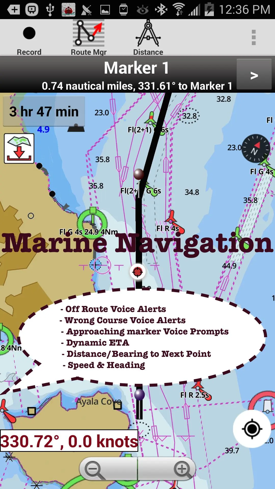
√ Route Assistance With Voice Prompts
* approaching boating route marker prompt
* Real time nautical distance & ETA
* sailing/boating off route/wrong direction
√ Record Tracks
►TIDE & CURRENTS
* High/Low Tides
* Tidal Current Prediction
* Active Current Stations
► SHARING
* Share tracks/Boat routes/markers/Waypoints
* Export GPX files.
► Satellite Imagery
► USA Marine Charts
*Texas Lakes: Texoma,Eufaula,Toledo Bend
*California Lakes:Tahoe, Shasta
Pennsylvania Lakes: Lake Raystown
Florida Lakes: Lake Okeechobee,Kissimmee
*Minnesota Lakes: Lake Minnetonka,Waconia,Leech,Mille Lacs
* Massachussets lakes Quabbin
*Missouri Lakes: Truman
*Ohio Lake maps of Lake hoover
*Wisconsin Lakes: Lake Winnebago,Pepin
* Utah Lake Powell,Bear
*Maine Lake Sebago
*Alaska Lakes: Lake Winnipesaukee
*Tennessee Lake Barkley,Norris,Watts Bar
*South Carolina Lake Keowee,Hartwell,Murray
*Lake Michigan,Huron,Ontario,Superior,Erie
► Canada Lakes Maps
* Lac Saint Jean
* Ontario Lake depth maps
* Rideau Canal-Ottawa River
* British Columbia Marine Charts
* Pacific Coast-Vancouver- Haida Gwaii
* Nova Scotia South-Bay of Fundy
* Quebec-Anticosti Island
* Newfoundland
* St. Lawrence river
* Manitoba & Saskatchewan
* Georgian Bay
* Puget Sound
► UK Nautical Charts
* Scotland
* Thames Estuary
* Ireland
► Australia Marine & Lake Maps
* NSW
* Queensland
Preview
Information
Developer
Gps Nautical Charts
Latest Version
235.0
Last Updated
2023-12-05
Category
Travel-local
Available on
Google Play
Show More
How to play i-Boating:Marine Navigation with GameLoop on PC
1. Download GameLoop from the official website, then run the exe file to install GameLoop
2. Open GameLoop and search for “i-Boating:Marine Navigation” , find i-Boating:Marine Navigation in the search results and click “Install”
3. Enjoy playing i-Boating:Marine Navigation on GameLoop
Minimum requirements
OS
Windows 8.1 64-bit or Windows 10 64-bit
GPU
GTX 1050
CPU
i3-8300
Memory
8GB RAM
Storage
1GB available space
Recommended requirements
OS
Windows 8.1 64-bit or Windows 10 64-bit
GPU
GTX 1050
CPU
i3-9320
Memory
16GB RAM
Storage
1GB available space