
Boating Marine & Lakes 電腦版
Navionics Srl
用GameLoop模拟器在電腦上玩Boating Marine & Lakes
Boating Marine & Lakes 電腦版
來自發行商 Navionics Srl 的 Boating Marine & Lakes 能夠在安卓系統上運行。
現在,您可以在電腦上使用 GameLoop 模擬器流暢地玩 Boating Marine & Lakes。
在 GameLoop 遊戲庫或搜索結果中下載。 不需要再暢玩遊戲時盯著電池電量或被令人懊惱的來電打斷。
只需在電腦大屏幕上免費下載暢玩Boating Marine & Lakes 電腦版!
Boating Marine & Lakes 簡介
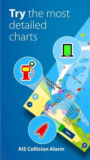
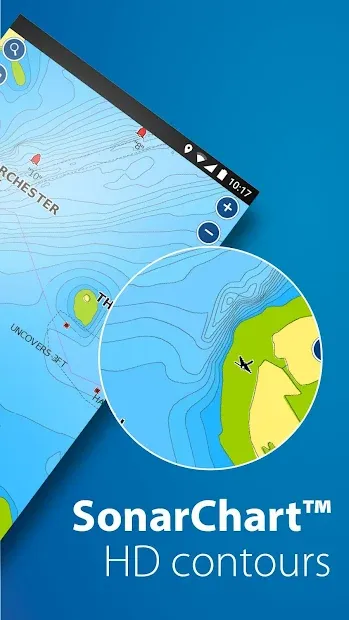
Let us be your guide. An indispensable app for cruising, fishing, sailing, diving and all your activities on the water. Get the same detailed marine and lake nautical charts and advanced features as on the best GPS plotters, and more. > TRY FOR FREE: Download the app and try all charts and features for a limited time. > SUBSCRIBE: Start your 1-year subscription to: - Download chart layers for offline use (permanent) - Access daily updates, chart overlays and advanced features (renewable) Use your subscription across your compatible smartphones and tablets by logging in to the Boating app with the same account. THE SUBSCRIPTION INCLUDES: > CHART LAYERS FOR OFFLINE USE - NAUTICAL CHART: A comprehensive cartography resource for lakes, rivers and marine areas. - SONARCHART™: An exclusive 1’ (0.5 meters) HD bathymetry map features extraordinary bottom contour detail enhanced by millions of sonar logs contributed by boaters. - COMMUNITY EDITS and ACTIVECAPTAIN® COMMUNITY: Crowd-sourced local information and points of interest shared by the Navionics® and Garmin ActiveCaptain boating communities. - U.S. GOVERNMENT CHARTS (NOAA): Available with the following coverage areas: U.S. and Canada, Mexico, Caribbean to Brazil, Pacific Islands, Asia and Africa. > DAILY CHART UPDATES: The latest charts are available via download, with up to 5,000 updates every day. > FEATURES - CHART OVERLAYS SONARCHART SHADING: A detailed rendering of the seafloor and lake bottoms in varying shades of blue offers a unique perspective of underwater topography at a glance. RELIEF SHADING: Highly detailed shading combines color and shadow to provide an easy-to-interpret, clearer view of bottom structure. SONAR IMAGERY: Shows bottom hardness in vivid color to easily identify transition areas. Available on select U.S. lakes. TERRAIN: Shows roads and useful points of interest on land. SATELLITE: Satellite images provided by a third party. - DOCK-TO-DOCK AUTOROUTING*: Start your trip with a suggested route based on chart data and navigation aids for advanced route planning that offers ETA, distance to arrival, heading to waypoint, fuel consumption and more. - CONNECTIONS: Stay in touch with friends and fellow boaters on and off the water. Share your profile, tracks, routes, markers and live location with your boating community. ADVANCED MAP OPTIONS: Customize your chart views to change chart-overlay combination, highlight shallow areas, target multiple fishing ranges and more. - WEATHER AND TIDES: Access real-time weather data, daily and hourly forecasts, as well as wind, weather buoys, tides and currents overlaid on your map. - GPX IMPORT/EXPORT: Easily handle your tracks, routes and markers. Share, store and display them on various apps, plotters and other compatible devices. - AIS: Connect the app to a compatible AIS receiver with Wi-Fi® connectivity to see nearby marine traffic overlaid on the map in real time. No internet connection needed. - PLOTTER SYNC: Transfer routes and markers, update charts and more to compatible plotters. - TIMELINE: Enjoy looking back at your trips in the track timeline. RENEW SUBSCRIPTION After 1 year, you can renew your subscription or keep using your maps with free features. FREE FEATURES - SONARCHART™ LIVE: Create your own 1’ (0.5 meters) HD bathymetry maps that display in real time while navigating. Connect the Boating app wirelessly to a compatible sonar/plotter. You can also automatically share your sonar logs, which helps us improve charts. - Includes track, route, distance, markers, wind forecasts, map options, sync my data, share location and more. NOTES: - Continued use of GPS running in the background can dramatically decrease battery life - The app is specifically designed to load and operate on devices with an OS of 5.0 or higher. - Wi-Fi is a registered trademark of the Wi-Fi Alliance. *Autorouting is for planning purposes only and does not replace safe navigation operations.
預覽
訊息
開發商
Navionics Srl
更新時間
2021-07-30
類別
Maps-navigation
同時可用
Google Play
更多
如何在電腦上用 GameLoop 玩 Boating Marine & Lakes
1. 從官網下載GameLoop,然後運行exe文件安裝GameLoop
2. 打開GameLoop,搜索“Boating Marine & Lakes”,在搜索結果中找到Boating Marine & Lakes,點擊“安裝”
3. 享受在 GameLoop 上玩 Boating Marine & Lakes 的樂趣
Minimum requirements
OS
Windows 8.1 64-bit or Windows 10 64-bit
GPU
GTX 1050
CPU
i3-8300
Memory
8GB RAM
Storage
1GB available space
Recommended requirements
OS
Windows 8.1 64-bit or Windows 10 64-bit
GPU
GTX 1050
CPU
i3-9320
Memory
16GB RAM
Storage
1GB available space