
TcpGPS - Surveying with GNSS PC
Aplitop - Surveying & Civil Engineering Solutions
قم بتنزيل TcpGPS - Surveying with GNSS على جهاز الكمبيوتر باستخدام GameLoop Emulator
TcpGPS - Surveying with GNSS على الكمبيوتر الشخصي
TcpGPS - Surveying with GNSS ، القادم من المطور Aplitop - Surveying & Civil Engineering Solutions ، يعمل على نظام Android في الماضي.
الآن ، يمكنك لعب TcpGPS - Surveying with GNSS على جهاز الكمبيوتر باستخدام GameLoop بسلاسة.
قم بتنزيله في مكتبة GameLoop أو في نتائج البحث. لا مزيد من الانتباه إلى البطارية أو المكالمات المحبطة في الوقت الخطأ بعد الآن.
ما عليك سوى الاستمتاع بجهاز TcpGPS - Surveying with GNSS على الشاشة الكبيرة مجانًا!
TcpGPS - Surveying with GNSS مقدمة
TcpGPS is an application for surveying professionals, which facilitates data collection and stakeout of plots, urban areas and infrastructures. It requires a high precision GPS/GNSS receiver.
Main features:
Base maps 🗺
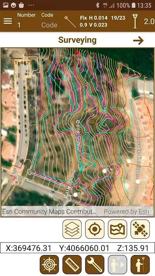
ESRITM base maps with worldwide coverage are used, which can be viewed in street, satellite or topographic mode. You can also upload files in DXF, DWG, GML, KML, KMZ and shape formats, both local and in the cloud and add web map services (WMS).
The program includes the EPSG database of geodetic systems, being able to work with different coordinate reference systems organized by countries, and local systems can also be defined.
Surveying 🦺
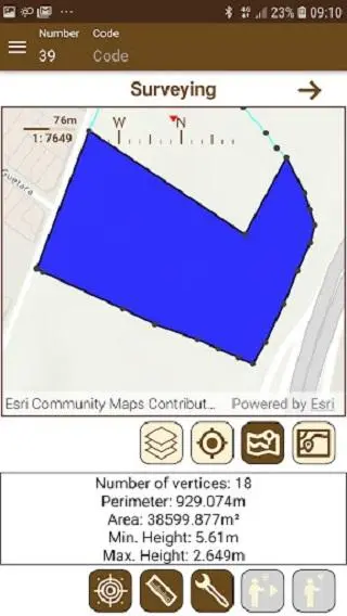
The application makes it very easy to survey topographic points and linear and polygonal entities, which are drawn in layers and with customized symbology. The continuous mode allows you to record points automatically, specifying a distance, time or slope interval.
TcpGPS controls at all times the type of position, horizontal and vertical accuracies, number of satellites, real time age, etc. and warns if any of the indicators is out of tolerance. It is also possible to set a minimum observation time and work with epochs.
Photographs, voice notes and optional codes can be associated to the objects, as well as user-defined attributes, ideal for GIS projects.
All collected data can be exported to multiple formats and shared from within the application, to be stored in the cloud or sent by email or other means.
Stakeout 📍
Points, lines and polylines of the cartography can be staked out, designating them graphically or selecting them by various criteria. The application offers different help modes, such as map, compass, target and augmented reality. Voice prompts or sounds can also be activated.
GNSS receivers 📡
The software allows you to easily connect to any NMEA-compliant receiver. In addition, you can configure various receivers integrated in the device or connected via Bluetooth, to work in base, rover or static mode and use corrections via radio or Internet with data from the collector or the equipment itself.
The status bar shows at all times the position type, accuracies, IMU status, etc. and supports GPS, GLONASS, BeiDou, Galileo and SBAS constellations.
Professional Version
Ambitious projects need tools that are at the cutting edge of technology to maximize productivity and achieve success.
The professional version of TcpGPS is very useful for working on road, railroad and linear projects in general, being able to import LandXML files and other formats. It is possible to stake out points with respect to the alignment, or specific vertices such as road edge, shoulder, curb, pavement footing... Specific options for slope control are also available.
The program generates the digital terrain model and contour lines from optional points and break lines. It is also possible to compare the current elevation with that of a reference surface.
معاينة
معلومة
مطور
Aplitop - Surveying & Civil Engineering Solutions
احدث اصدار
2.7.0.1
آخر تحديث
2024-02-09
فئة
Maps-navigation
متاح على
Google Play
أظهر المزيد
كيف تلعب TcpGPS - Surveying with GNSS مع GameLoop على جهاز الكمبيوتر
1. قم بتنزيل GameLoop من الموقع الرسمي ، ثم قم بتشغيل ملف exe لتثبيت GameLoop.
2. افتح GameLoop وابحث عن "TcpGPS - Surveying with GNSS" ، وابحث عن TcpGPS - Surveying with GNSS في نتائج البحث وانقر على "تثبيت".
3. استمتع بلعب TcpGPS - Surveying with GNSS على GameLoop.
Minimum requirements
OS
Windows 8.1 64-bit or Windows 10 64-bit
GPU
GTX 1050
CPU
i3-8300
Memory
8GB RAM
Storage
1GB available space
Recommended requirements
OS
Windows 8.1 64-bit or Windows 10 64-bit
GPU
GTX 1050
CPU
i3-9320
Memory
16GB RAM
Storage
1GB available space